Posts

Certain Guyots

Image
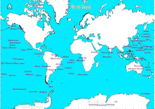
 Guyot happens to be almost flat submerged oceanic seamounts generated through oceanic wave gyre erosion effect over relict spreading center volcanic hot spots.Either oceanic emergence or volcanic submergence being the cause of such evolvement that deliberately emits gaseous product inducing the sea surface level temperature and certain other stimulating topospheric events.The Western Pacific containing plenty of such features.There being numerous in quantity,however approved a few nowadays.Prof Harry Hammond Hess surveyed through echo sounding during 1945 termed tablemount mesas like features as Guyot in honour of Prof Arnold Henry Guyot having two hundred metres flat summit (660 feets) beneath the sea surface.Indian ocean consisting of 28 guyots,Mediterranean and Black seas 2 Guyots,North Pacific 119 Guyots,South Pacific 77 Guyots,North Atlantic 8 Guyots,South Atlantic 43 Guyots,Southern Ocean 6 Guyots with a total of 283.Tablemount's 42% are there in North Pacific having an area

Territorial Production economic complex

 Territorial Production combination economic complex notion formulated by soviet geographer, Prof  N N Kolosovskiy during 1947 reprinted as Principles of Economic Regionalization in 1958 that being translated by Prof Lawrence Ecker .Territorial Production Complex ought to have a diversified economy,mutual conditioned interrelated economic activities as well as a common territory. Territorial production complex is being synchronized with regional resource utilization technical know how as well as tranportation capability and Industrial Production combination efficiency compensated by labour intensive utility along with mechanical technological progress achievable by Power availability.Territorial production complex creates certain Industrial economic cycle of resource utilization that being motivated by sequence occupant cultural traits prevailing in a particular region.An agricultural raw material generation surplus region could have basic industrial infrastructure production cycle con

Geoarcheology

 Geoarcheology collaborates multidisciplinary approach comprising of Geography, geology, pedology,stratography, anthropology like related fields of study for excavating paleoenvironment of a particular archeological site. Prof A D Davidson and Prof L M Shackley through their accomplishment Geoarcheology; Earth science and the Past along with Prof Fredrick Everard Jeuner efforts being the prominent consideration regarding Geoarcheological curiosities. Sciencedirect

Geopsychology

 Geopsychology conveys personality traits to be influenced by surroundings prevailing in one's social political economic as well as cultural spheres of existence.The regional immediate surroundings with ethnic domain of national associative features of overlying subjugative implications carried away one's aural presence in disguised spooky manner.The eightees CANOE geopsychological personality traits characteristics being conscientious, agreeableness,neuroticism,openness and extraversion. Bigthink

Biochore

 Biochore are biosphere inherent regimes comprising of biotypes which are morphologically identical,however physiographically different that are being overall endemism of their biota inside a geographic surroundings within a core area.Prof Raunkiaer propounded the terminology to associate exact paleobiogeographic delimitation of climatically distinguished plant domains and their principal subdivisions.There being four major biochore prevailing across the planetary surroundings namely as grassland biochore, desert biochore, savanna biochore as well as forest biochore. 

Global city

 Global city of diverse cultural pluralism as well as economic hub of dominant infrastructure notion being popularized by Prof Saskia Sassen through 1991 accomplishment Global city ; New York, London & Tokyo book.The accumulation of wealth in fewer ellites with a disconnected regime in between city & respective regions owing to marginalized larger demographic proportion managing their living, compromised by a differential quality of life.Global city index formulated with twenty seven metrics consisted of five dimensions of human capital,information exchange, business activity, political engagement and cultural experience.

Conurbation

 Conurbation terminology being propounded by Prof Patrick Geddes during 1915 constituting continuous along with urban comprising of atleast fifty thousand core habitat with outergrowth for socio economic linkages formed by combination of two or more city.A conurbation encompasses rural urban continuum beyond it's administrative regimes as for example Kolkata Howrah dual mutual contiguity.US recognizes such connectivity being standard urban area previously as Metropolitan statistical area as Standard Metropolitan statistical area having one or more counties.Demographic increments with technological and Industrial progresses along the major routes gradually extending city outgrowth for combination being conurbation.The morphological structure along with regional subconscious naming notion for economic centres of retail and wholesale could be influencing factor for such unification.

Cultural ecology

 Cultural ecology is human adaptation with surroundings processual archeological ecological diachronical evaluation of entities pertaining to different epochs as well as materiastic syncronical consideration present along with various components.Cultural ecology concept propounded by Prof Julian Steward encompassing Prof Franz Boas anthropological Distribution of wealth and power in a society.Prof Steward suggested technical mechanism for environment resources utilization in order to achieve a living for sustainability.The associative pattern of cultural adjustments with surroundings being considered for cultural traits, cultural realm as well as cultural complex implications.Prof Carl O Sauer landscape morphology concept as well as Prof Stoddart agricultural decision initiative notion are certain consideration for cultural ecology emphasis.
 Prof Edward Augustus Ackerman identified human resource regions based upon Technology factors, Resource factors as well as Population factors.Prof Ackerman considered Technology as most dominant factors as resources couldn't be utilized without proper technological achievement.There being American type pop resource region,European type pop resource region,Egyptian or Chinese type pop resource region, Brazil type pop resource region as well as Arctic type pop resource region.
 Circular economy conveys raw material production for use with recycling involving nothing being left for external environment as the nature in the surroundings works encompassing different constituents for homeostasis mechanism.Recycle Economy is the one that encorporates raw materials production use recycling done,however, non recyclable material being left untreated.Linear Economy involves production use and thereafter leaving materials as non recyclable waste without recycling.

SDG

 Millennium Development goal on completion extended as Sustainable development objectives having seventeen objectives and one hundred sixty nine targets along with two hundred thirty two indicators, adopted by one hundred ninety three countries since Twenty fifth of September Two thousand fiveteen . The high level Political forum on sustainable development under the patronage of U N Economics and Social council being the monitoring entity guiding State actors and Non-State actors for optional choices to consider in their respective spatial locality depending upon financial grants and exposures outmaneuver.Sustainable development goal one being ending poverty all across upto 2030 comprising of benefitting all guaranteed equal rights for social amenities.Sustainable development goal second is achieving food security everywhere meaning thereby zero hunger.Sustainable development goal third being good health and well being for all at all ages.Sustainable development goal fourth is ensuring

Prof Gordon Childe urban development theory

Prof Vere Gordon Childe's New light on the most ancient East described social change as revolution.'Man makes Himself' accomplishment joined Bronze & Iron age revolutions into singular Urban revolution resembling anthropologist Prof Lewis H Morgon civilization concept, recognizing Neolithic revolution as a radical change consisting of nomadic lifestyle to subsistence and livestock farming status thereby improving demographic statistics as well as the food stock. Prof Gordon Childe considered ten traits persistent in older cities ● Extensive enhanced settlement in comparison to earlier, however, lesser than even various villages nowadays ● Encouragement for professional specialist craftsmen,merchants,officials, transport workers & priest ● Technically inefficient hard-earned surplus offerings presented to divinity present or imaginary ● Monumental awesome public architecture signifying social surplus concentration ● Prevailing Inequality comprising of social surplus
 Edge city notion resembling particular city outskirts formulated by Prof Joel Garreau during 1991 in his book Edge city:Life on the New Frontier, considered certain criteria for notifying Businesses,Shopping & Recreational area to be called Edge city, such as ; Comprising atleast half crore square feet leasable office area, encompassing six lakh square feet or more leasable retail space,greater jobs with respect to bedrooms count,fulfilling local perception of an integral place as well as modified through a suburb residential or rural place for about thirty years of duration.Advantages being Secondary commercial areas of Corporate headquarters having Sylvan campuses along with office access ease for smaller companies in monotonic surroundings whereas disadvantages could be the urban sprawl ignoring public transportation enhancing pollution.The Peripheral city model includes such Postwar suburbanization.
 Indian laureate differentiated rural settlement as Mauza & Majra.Rural settlement are broadly classified spatially into four main type Compact,Fragmented,Hamleted & Dispersed on the basis of habitat distribution.Prof Hudson is credited for rural settlement theory.Rural morphology major types are Linear,Checker Board,Radial,Arrow,Circular,Fan shaped,Star pattern, Honeycomb,Rectangular and Irregular pattern.
Image
 
66th Global Environment facility council covers climate,biodiversity,land degradation,International waters,chemicals & Waste focal areas having a total $916.1 million with finger crossed to generate $ 7.53 billion through co-financing.GEF being established on the eve of 1992's Rio Summit to tackle pressing environment adversities like air pollution,food waste,Global warming,Ocean acidification,Drought,Damages Ozone layer,Oil spils,Water Scarcity,Plastic Pollution,Overpopulation,Extreme Weather,Energy Consumption,Overfishing,Biodiversity loss,Climate Change,Environmental degradation,Desertification,Wildfires,Environmental Issues,Resource depletion.
 Mesmerizing the world of urban geography,  where cities evolve and grow to become service centers for their surrounding areas.  Urban geography deals with the environment of cities,  including the distribution of people, buildings, facilities, institutions, and culture within the cities.  It also encompasses the site, evolution, pattern, and classification of towns.  As urban geographers, we are concerned with interpreting the patterns and relationships within urban areas and guiding urban growth and development to promote a better urban way of life.  Urban geography focuses on the relationships between industrial land use in cities and other forms of urban land occupancy.  It is concerned with the city as a functional and physical entity,  examining and measuring urban relationships and their regional variations.  The distribution of settlements represents real differences in functions that are significant for the same population groups.  Urban geography is essential for understandin
Image
  During the ancient Ayodhya period, the main feature of city planning was the canal and pond infrastructure located on its boundary premises, which was used for irrigation, drinking water, domestic and industrial use, which also provided natural protection to the environment, which in modern era being called as Crime prevention through environmental protection. It could be easily manifested in Shahabad region because this region is delimited by Ganga and Son rivers. The C•P•T•E•D• notion being propounded by Mr. C Ray Jeffrey.Certain kind of changes in the environmental scenario provide a situation of comparative advantage to the oppressive obesessive pesonalities, due to which they directly violate the social rules, become domineering and gift the resources obtained through corruption to the opposite sex and use them for unnatural satisfaction as per their wish.In contrast to such circumstances, environmental management planning that provides human ecology and social security, such as
 Imagine a world where glacial meltwater is accessible to all, enhancing the intelligence of common people.  The mineral richness of glacial ice remains unmatched by conventional water purification methods.  Arctic and Antarctic melting, compounded by global warming, affected by the quality of water available to commons metaphysically as the spooky disturbances arosen due to lack of quality water enhance the glacial melting.  The repercussions of inadequate water intake can lead to various health issues and unsettling disturbances.  Anthropogenic factors play a significant role in the accelerated melting of glaciers, impacting water resources.  Let's strive for a collective effort to preserve our glaciers for the well-being of future generations.  If we don't witness positive changes soon, we risk losing the invaluable natural beauty of our planet.  The delicate balance of nature is at stake, urging us to act responsibly and with urgency.  Water is life's essence, and safeg
 India hindi version popular name Bharat meaning cherishing,supporting,bearing,pursuing light signifying knowledge.Rigvedic Bharata tribe & Vayupuranic contexts have such etymological stories too, Mahabahrata's ancient king Shriman Dushyant & his beloved consort Shrimati Shakuntala's son Bharat Chakravarti. Bharat being named after a renowned king Shriman Priyavarta's great grandson progressively in succession with his descendant,King Abhinetra's son, King Shriman Maharaj Nabhi whose grandson as well as son of Raja Rishabhdev,Shriman Bharat.India name derived through the notion that one would be required to cross the etymological river to be here. India consisting of 28 states & 9 union territories covering vast area having Northern limit at Indira kol whereas Southern extremity being at Indira point. Easternmost limit is at Kibithu, Anjaw & Westernmost extent being at Guhar Moti in Kutch near Sir Creek. Physiographically classified in six obvious divisi
Image
 

Global Village

 The media laureate Prof Marshall McLuhan propounded the concept of Global Village through his The Gutenberg Galaxy;The making of typographic man 1962 and Understanding Media 1964 to acknowledge that interconnected global sphere have profound impacts in multi diverse Global local continuum scenarios.The digital age Glocalization via alteration of global processes by local individuals meditating for reterritorializtion generating an aspect of popular culture in context of their local culture accepting to be their own.

Submarine canyon

 Submarine canyon akin to terrestrial canyon evolved across continental shelf & slope through glacial or non glacial inundated river delta abyssal fan deposition erosional valley submergence having steep sided valleys or deep valleys evolved by Sub-aeriaĺ erosion,Diastrophic convection current,Submarine mudflow & landslide,Submarine density current,Turbidity current erosional abyssal fan as well as Submarine spring sapping slumping.Active marginal canyon being numerous widespread than passive marginal dendritic compact.Almost thousand (9,477 ) observable as miniature turbidity current channels resembling as water flow channels above sea level.The emergence of continental shelf during different chronological epoch along with cyclic submergence initiating ďepositional river materials erosion as well as canyon valley creation by different mechanism like convectional current, turbidity current, oceanic gyre density current,tectonic events etc could be the reason for various submari

La Nina

 During the cold phase of ENSO there being cold sea surface temperature exist in vicinity of Peru formed by the intensification of Walker cell circulation due to Easterlies along the equatorial Pacific that is linked to female younger sister to the El Nino,called as La Nina.As Southern oscillation index is negative in case of El Nino,the SOI remains positive for La Nina with air pressure being higher at Tahiti than Port Darwin. La Nina is strengthening of Enso neutral phase with a descending limb at Eastern Pacific owing to high pressure conditions along south American west coast and ascending limb at western Pacific near East coast of Australia due to low pressure in prevailing warmer water.La Nina being associated with a negative Indian ocean dipole in relation to native surroundings. 

El Nino

The northern Peru is used to Humboldt cold current flowing farther away from the south.However, during occasional year completion duration,sea surface temperature increases expectionally being known as El Nino.Prof Gilbert Walker calibrated air pressure difference between Tahiti and Darwin.If Tahiti at higher temperature than Darwin,the southern oscillation index is believed to be positive and otherwise negative conveying east west variational oscillation.The El Nino Southern oscillation neutral phase,walker circulation consisting of Western Pacific (East Coast of Australia) rising warm limb owing to low atmospheric pressure conditions whereas the Eastern Pacific ( South American Western Coast ) comprises of high atmospheric pressure,marked by descending cool limb.The warm water flows towards Western Pacific owing to Easterlies blowing through the Andes enhances thermocline depth that elevates Sea surface height relatively higher than Eastern Pacific. During Warm phase,this Walker circ

Carbon tax

 Carbon credit involves Carbon ton equivalent certification in exchange of other GHG rights through International Emission trading,Clean development & Joint implementation mechanism along with carbon trading by emission & offset trading for Nationally determined contribution reducing emission by 45% & 50% renewable power generation capability along with net zero emission upto 2070.India being seventh for carbon emissions regulated by CERC for carbon credit trading & BEE considered schemes & entities obligation targets.Carbon taxes are opposed as production cost would increase with GDP alterations hamperd by Industrial burden as carbon taxes are explicit price instruments not determined by emission limits.Implicit carbon pricing such as fuel excise taxes, fuel subsidies are considered as per Oecd.Since, August 2022 carbon credit export being withheld.One metric ton of carbon emissions being equivalent to one tree carbon dioxide absorption in 40 years.One tree offsets

Datum

 Geodetic datum being the reference coordinate system to protray the surface geomorphological size and shape characteristics of the planet encompassing the coordinate system considered for mapping origin and orientation obligations.The conversion of a particular coordinate system through different datum requires seven parameters,in which three being translational deviation parameters in x,y,z axis,another three rotational parameters in x,y and z axis and remaining one to be scalar factor.Ellipsoidal semi major axis & flattening features change values too essential.The WGS 84 (world Geodetic system,1984) is considered for entire planetary geoidic heights referencing through the centre of mass of earth as origin.The Indian spheriodal datum being Everest 1830 modified in 1880,1930,1956.The transformation parameters between the WGS 84 and local coordinate system vary from one place to another adjusted by mathemaical equations.A datum shift minimizes such calculations as the deviation c
Social progress Index developed by Prof Amartya Sen,Prof Douglass North and Prof Joseph Stiglitz encompassing fourty nine indicators for India having three vital dimensions as basic human needs,Well being foundations and Opportunity.India got 58.06 out of 100 managing a rank of 111 among 170 countries.  Legatum Prosperity Index of previous available year for India being 103 rank out of 167 countries covering 104 variables in 9 sub groups as economic quality 89th,Business environment (Investment environment 70th,Enterprise conditions 39th,Infrastructure and market access 84th) , Governance 54th, education 106th,health 112th,Safety and security 138th, Personal freedom 112th,Social capital 124th and Natural environment 161th.
 Consociationalism being integration of social divisions based on ethnic,linguistic,religious, classes or casteism for stable democratic state according to proportional representation,recognized by Prof Arend Lijphart initially.Prof Ted Gurr propounded relative deprivation being expectations enhancement without capabilities leading to discontentment in political regimes measured by the scale of gap in between objectives considered and achievement accomplished actually in terms of economic conditions prevailing through distribution of wealth.Prof Lijphart conveyed four characteristics of consociational democracy namely Grand Coalition,Mutual veto,Proportionality as well as segmental autonomy.
Image
Prof Przeworski once stated democracy being the institution through which Parties lose election. Introduced democracy dictatorship index that being further developed by Prof Cheibub Gandhi and Prof Vreeland categorized democracy into Parliamentary,Semi-Presidential (mixed) and Presidential democracy as well as dictatorship into Military,Monarchic and Civilian dictatorship.Some of the noteworthy indices of democracy being Pedersen index measuring political volatility which is 25.1 for native country,Voter tunout (participation index),efficiency gap (wasted votes in first past the post system),Political Efficacy (Internal & External commitment as well as demand of an Individual 's party participation).Freedom in the world,India's 2024 rank being 66,economic freedom as 52.9 being mostly unfree,2023's Press freedom Index as 36.62 being very serious and democracy index of 2023 being flawed democracy as 7.18 

Electoral Party classifications

Otto Kirchheimer's Classification-Broom party or catch-all party of socially heterogenous secular spectrum. Angelo Panebianco classification-Mass Bureaucratic party of competitive political administrative role as well as Professional New party. Max Weber classification-Party of Notables & Party of Masses signifying internal structure.Objective based classification as Patronage parties and Ideological parties. Robert Michels classification-Clientele parties authorizing single entity,economic or social interest biased parties and Doctrinal parties having political ethic constituents. Maurice Duverger Classification-Renowned distinguished members of society devoting quality to members number consisting of autonomous units randomly organized lacking discipline.Mass Parties with stable pyramidal structure.Cadre parties being sporadic and election focussed. source;https://web.archive.org/web/20020805142547/http://www.bcn.cl/pags/instituciones/partidos/4_clasificacio_pp.htm  

Duverger's law

 Prof Maurice Duverger propounded the hypothesis for First Past the post system stating that electors tend to concentrate more commonly for two major party with a consideration that votes being valuable therefore voting for minor party could waste votes as vote splitting may divide votes in a multiple choice prevailing legislature.      https://democracyjournal.org/magazine/70/giving-minor-parties-a-chance/
 

Cultural Assimilation

 Cultural Assimilation incorporates minorty ethnic communities being compelled to accept adament dominant culture.If complete assimilation persists then considered as like Acculturation that being a kind of adaptation to certain alien cultural surroundings.Whereas if there being certain space for retaining one's own primitive values then termed as cultural integration encompassing cultural diffusion of dominant culture.Forced Assimilation may lead to revolt,however Voluntary Assimilation is maintained for life safety and other temptations being required for sustaining one's survival.Assimilation fuses sentiments as well as behaviours for blended dominant culture aspects.Religious Assimilation similarly considers following the dominant faith even being social construct having weird illusions comprising of paradoxes prevailing in epical discourse.Religious assimilation involves conversion of minorty faith to dominant faith which is essentially mandatory for immigrants and certain

Proposed MMLP

Image
 Multi modal logistics Hub is a collaboration of logistics (supply chain Management) service providers and freight processes for multiple transportation ease of trucks carrier,rails carrier,air cargo freight,waterways carrier for efficient warehouses storage capabilty designed for inter modal container transfer material handling container terminals.There being thirty five Multi modal logistics parks recognized by MoRTH.ESR being the largest and Nagpur known as logistics capital of India.India got 38 rank out of 139 countries devoted for logistics having Logistics market estimated to be USD 317.26 Billion with an annual 15 to 20 percent growth rate.General Augustine warner Robins known as father of logistics.First International Multi Modal Logistics park is developing in Jogighopa,Assam.Muddelinganahalli,Bengaluru encompassing an area of 400 acres being one of the largest MMLP following Gati shakti National Master Plan.There being MMLP established at Vishakhapatnam,Naya Raipur,Balli,Dah

Statutory town

 The urban local bodies like Municipal  Corporation ,Municipality, Cantonment Board ,Notified Town  area committee,Town Panchayat, Nagar Palika etc comprising of atleast seventy five percent of population engaged in non agricultural occuption,consituting a density of four hundred square kilometers are known as statutory town.However,Census town considers population exceeding five thousand as well as seventy five percent main working population engaged in non- agricultural sector.Thus, a Census town is not administered as a town and being statutorily notified,however attained the urban characteristics.There being 4,657 (4041) statutory towns and 5,050 (3,892: 3,784)  census towns prevailing in India with almost 6.4 lac villages and 7935 towns.Statutory town exceeding one lakh inhabitants could be categorized as cities.As Town beyond one lakh inhabitants,administered being a Municipal Council (Municipality,Nagar Palika,Nagar parishad or Nagar Plaika Parishad),a city becomes Municipal cor

Industrial Corridor

 Industrial Corridor being an infrastructural financial inclusional package framework for ultra modern amenities for sustainable Industrial cluster development encompassing spatial arterial modality of advanced ports,highways as well as railroads.Incorporating National Industrial corridor programme for Plug and play infrastructure in attaining uniformity through resilient development and sustainable futuristic smart cities.NICP designed for eleven Industrial corridor consisting of four phases along with national Infrastructure Pipeline. Delhi Mumbai Industrial corridor;DMIC developed throughout 1504 km dual side alignment along Western Dedicated Freight Corridor(WDFC) in midst of Dadri and Jawaharlal Nehru Port Trust.U.P.,Haryana,Rajasthan,Gujarat,M.P. & Maharashtra states are being the project beneficiary regions undergoing overall socio economic development National Industrial corridor development and Impementation trust (NICDII) as well as National Industrial Corridor Developmen

Possibilism

Nature shapes our surroundings, offering possibilities for adaptation and sustainability. Human civilization adjusts to its environment, creating a unique lifestyle.  Prof Vidal de la Blache suggested that nature determines the limiting topographic surroundings, however provides habitational conditions as well as traits to adapt in certain region by developing possiblistic notions to cope up against any odds. Homogeneity does not define human destiny; possibilities are everywhere. Possibilism grants options for sustainablity, depending upon the behavioral humanistic ethical constraints. Genre de vie being lifestyle as the resultant of human civilizational adjustment with their surroundings. Nature is permissive, not mandatory, allowing human influence. Prof Jean Brunches proclaimed as Nature is not mandatory however permissive. Regions are shaped by human capabilities and acquired characteristics. Prof H J Fleure classified regions not biased upon the natural biotic factors of surround
Image
  Prof John Heinrich Von Thunen being a manager of an agricultural estate in Rostock,Mecklenburg propounded agricultural locational rent of land use distribution through fourty years of experience during 1826.The locational rent or economic rent is a comparative advantage for the farmer willing to afford highest rent that one could bid for the parcel of land encompassing total revenue generated from crop sale marketing considering the production and transport cost expenditures.The land use distribution depending upon marketing distance assumes that there being an isolated region surrounded by a uniform agricultural plain having a single central city market.The Peasants are rational profit maximisers selecting variable cropping pattern owing to demand and supply considering the crop market prices bearing equal production costs.Transport cost is proportional to crop weightage output in an accessible marketing distance.The model suggested a concentric zone model constituting a land use pa
Image
  Although there should be a high correlation between vote percentage and seat number, sometimes votes are lost due to caste and community polarization. By not voting in the name of development, the public often develops a confused mindset based on verbal communication based on mutual affection of local background. They elect their representatives according to the same bias. In a successful democracy, there should definitely be a difference in the election decision-making ideologies of the Village Chief, MLA and MP.  Even Pure water couldn't have been provided to all.Water purity of the yojna implemented ought to be checked.The canal lining is not at par.The canal vicinity areas are liable to water sanitation effects considering Prof Darcy's percolation underground water flow regimes.The canal lining unattended lead to water inundation as throughout water infiltrates inside therefore the acqifer recharge capacity being already saturated therefore even a meager rainfall creates

Planetary varying climate characteristics

 Tropical rainy climate being warm with no cold season obtaining precipitation beyond sixty inches or more than 1523 mm/year rainfall with no distinct dry season located in equatorial zone. Tropical wet and dry climate being warm with no cold summer getting precipitation around 25-60 inches or 635-1523 mm/year rainfall,rainy summer climate lying in 5° to 20° latitudinal range. Steppe climate with hot and cold seasons comprising precipitation in range normally 10 to 20 inches or 254-508 mm/year located in subtropical and middle latitude. Desert climate with hot and cold seasons in interior regions otherwise constantly cool in subtropical coastal zone with precipitation normally less than 10 inches or 254 mm/year located in subtropical and middle latitude (sheltered and interior continental and some cold current coastal positions) Dry summer subtropical climate,warm to hot summers,mild but distinct winters obtaining precipitation in range 20 to 30 inches or 508 to 761 mm/year having dry
Prof Thornthwaite's climatic classification introduced in 1931 and modified upto 1948.Precipitation effectiveness and temperature efficiency being the dominant factors that influence climatic classification.Precipitation effectiveness impacts vegetative genesis and growth through the portion of groundwater recharge obtained out of total annual precipitation.The Precipitation effectiveness ratio evaluates such measurements,computing total monthly rainfall to that of total monthly evaporation.P/E ratio   =11.5(r /t-10) 10/9  where r being average rainfall in inches and t as average monthly temperature in degree Fahrenheit whose summation for twelve months calculates the annual precipitation effectiveness index ;Σ 11.5(r /t-10) 10/9  .There could be five humid regions classified in which five distinct vegetation prevails;A as Wet region having Rainforest kind of vegetation comprising of P/E index beyond128. B being Humid region representing Forest consisting of P/E ratio in between 64

Climatic classification

 Spatial planetary regions have different climatic conditions owing to various varying regional overlying parameters.Climatic classification criteria could be Empirical consisting of measurable quantitative weather affecting factors like precipitation effectiveness and potential evapotranspiration,Genetic classification encompassing conceptual climatic evolving facts as well as Behavioral classification relying over effects to cope up such climatic conditions.Prof Wladimir Koppen considered temperature and precipitation average monthly and annual variability over different vegetative regimes characteristics influenced by precipitation effectiveness.Vegetation growth being impacted by precipitation magnitude as well as evaporation intensity influenced by temperature ,wind speed like factors.Initially climatic classification introduced during 1918 and further a revised version published in Grundriss Der Klimakunde during 1923.Later a collaborative Prof Koppen- Prof Geiger effort introduc
Image
 

Glacial morphology

 Piedmont glacier-Initially Ice cap transforming for mountain glacier encompassing passive englacial as well as supraglacial flow outward accompanied by an active basal sliding across upper surface gentle sloping in which mountain valley being totally occupied and overflowed through the foreland coalescencing the adjacent flow for ice apron formation.The Cirque in juvenile conditions forsees the ice flows besides rock divides accompanied by streams transecting the range which provides a pass whenever the glacier melted away.Grimsel pass,Switzerland;Malaspina glacier,Alaska Expanded foot Glacier- Glacier thermal regime once becoming milder,the glacial streams apparently obvious having lesser penetration through the subglacial channels in a fully captured valley,associated with an overflow upon the foreland,adequate enough for ice apron formation. Dendritic Glacier-Represented by a partial valley submergence having tributary ice streams besides the supraglacial main flow accompanied by a

Karst landforms cycle of erosion

Image
Karst being derived from french word "causses" utilized by Baring Gould in reference to the french desert topography for the english reader.Prof Johann weikhard von Valvasor underground flows of Cernicka,slovenia also being credited for the terminology.Prof Cvijic Karst erosion cycle in 1918 encompasses four main stages of evolution of karst topography.Youthful stage associated with premature undergroud drainage that resist rainfall runoff infiltration owing to carcks and crevices recharge having sustainable lakes.Further beyond this stage,subterranean drainage evolve that collect the whole surface runoff capable enough for Intermittent lakes formation.Next stage being marked by total surface runoff undreground percolation generating perfectly drainage system constituting no lake.However,if the karst landform surface base level subsidises below the water table saturation zone,lakes could appear.In nutshell,karst landform surface evolution is being consistently simultaneous wi

Karst topography

Calcite landforms evolved erosional and depositional topography known as Karst topography for which solution being the determinant factor out of several other ground water percolation physical processes like solution,hydraulic action,abrasion,attrition etc. Karst landscape etymological naming is derived from Adriatic sea vicinity Croatian karst region,formerly known as Eastern Yugoslavia.The important prevalent conditions required for such topographic genesis being extensive valley having joints & faults with perpetual precipitation with optimum impervious rock strata through which carbonic acid formation for seepage occur from acidic calcite and carbon dioxide reactant resultant carbonic acid.Some Karst topography lying in India being Robert cave,Panchmarhi,Vishakhapatnam as well as Rohtas Guptdham cavern. Erosional karst landforms topography; Lapies -Calcite surface solution provoked uneven cleft and pinnacles dalmatian topography,known as Klint in Britain, Bogaz in serbian regi

Slope development

Professor Davis slope succession theory considers bottom to top approach making convex valley sides profle at the top by soil creep that eventually become concave downward with graded slopes having moderately coarse debris coverings that become fine textured at depth.Slope decline concept concludes debris exchange downward propagation manifesting slope profile shape depending over erosional stage.Youthful stage foresees steep slope through vertical erosion generating convex slope.Mature stage encompasses interfluvial watershed headward erosion and lateral erosion slope graded profile.Older stage grade reduction relief minimization contributes to peneplain.Prof Penck's slope replacement considers erosional intensity crucial for slope morphology deducting convex slope through rapid erosion then monotonous erosion rate creates rectilinear slope that finally become concave through decelerated rate of erosion.Prof Alan Wood slope evolution considered Convex scarp followed by cliff free

Growth Pole

 Growth Pole theory propounded by Prof Francois Perroux during 1950's identified core industrial propulsive sector prosperous in certain region attracting investments dominate the central economy of a particular state constituting hierarchical levels of economic centres agglomeration.Prof Jean Boudeville during 1960's further recognised such growth centre equipped with natural resources and sound infrastructure,claiming regional disparities could be reduced through investments from such growth pole.Prof R P Misra developed growth poles & growth centres in reference to native regional and urban development situations recognising growth foci having multiple hierarchy relying over regional economic parameters.Prof Joseph Schumpeter known for creative destruction capitalism concept through his capitalism,socialism and democracy;1942 identified economic development being concentrated around innovation,enterpreneurship as well as marketing propulsive forces suggested fundamental

Dasymetric

 Choropleth mapping being represented by shaded areal proportional pattern associated with a particular portraying variable of quantitative or nominal data having standarized attribute value constituting rates,ratios,percentages, developed initially by Prof Baron Pierre Charles Dupin during 1826.Ex; election map of constituent assembly representing discrete portraying of continuous field akin to spatially intensive variable underlying a statistical surface.Spatially extensive variable having raw data as  totals,counts are represented by proportional symbolic mapping technique. Chorochromatic map are qualitative area nominal class dataset resembling spatial coverages through various symbols developed by Prof Heinrich Berghaus. Example;Demographic data suggesting dominating ethnic belief for twenty eight district & nine union territory having non hindu followers being prepared by thorough spatial data inputs would have irregular boundaries relying over the real locational coverages.

Meander

Meander is a tortuous curvy passage of stream channel progresses through base level relative change by eustatic,isostatic or tectonic kinds of upliftment acquiring the distinctive shape due to erosion at the outside concave bend as well as deposition over the inside convex streambank bend owing to fastest flow speed at outside cutbank and slowest flow speed across inside forming point bar in a presumed antecedent drainage topography during middle mature stages.The etymological name derived from the Buyuk Menderes river of Asia Minor,often represented by stream sinuosity index signifying deviation from the stream actual path with respect to expected theoretical straight passage being denoted by ratio between channel length to that of stream basin length having 1.5 beyond irregular value, tortuous as 2.1 further value designated as meandering. Incised meander is a vertical erosional incision downward in a stream channel during the rejuvenation following a uplift encompassing renewed deep

Isogram

 Isotherm -mapping locus of points connected to represent a contour line signifying equal temperature ; Isothere -mapping locus of points connected to represent a contour line signifying equal mean summer temperature ; Isocheim -mapping locus of points connected to represent a contour line signifying equal mean winter temperature ; Isogeotherm -mapping locus of points connected to represent a contour line signifying equal mean annual temperature ; Isotalantose -mapping locus of points connected to represent a contour line signifying equal range of mean temperatures underlying hottest & coldest months ; Isohel -mapping locus of points connected to represent a contour line signifying constant solar radiation ; Isoneph -mapping locus of points connected to represent a contour line signifying equal cloud cover ; Isohyets -mapping locus of points connected to represent a contour line signifying equal precipitation ; Isobronts - mapping locus of points connected to represent a line signi

Core Periphery theory of Prof John Friedmann

Core-Periphery model of regional development propounded by UCLA's  Prof John Friedmann during 1963-66 stating the central Core developed entities either global or regional level dominates the Semi Periphery as well as Periphery in economic,cultural as well as political spheres.There being four stages of development 'Pre-Industrial' being isolated free regional trade,'Transitional' in evolving sense for progressive growth of a distint core, 'Industrial' core and Periphery emergence for monotonous development constituting a integrated hierarchy and 'Post Industrial' mutually cooperative mercantilism economy having detached Periphery.A Core is a technologically innovative wealthier powerfull entity whereas Periphery being the human resource and raw material resources fulfillment zone.Semi Peripheral region like India having moderate status of economic development dominating over the Periphery while a lesser dominance with the core.There could be several

Morphoclimatic zones

Image
Landforms resembling a particular climate being the morphoclimatic regions propounded by Prof Jean Tricart and Prof Andre Cailleux based on paleoclimatic factors having subdivisions associated with interrelations among various principles such as geomorphology as well as biogeography.Prof C A Cotton in 1942 identifies six morphoclimatic regions;1)Normal-Under Davisian sense humid temperate landforms 2) Glacial-Following Davisian glacial,however excluding Periglacial 3)Humid -Processes & forms considered by Prof Sapper & Prof Friese having transitional Normal and Savanna regions characteristics as tropical virtue 4)Arid-Associated with topographical Bajada having Pediment extension linked with replacement of desert mountains through low domes as well as slope retreat,encompassing occasional fluvial sheet & stream flood.5)Semi-Arid- Transitional consisting of slopes breakings less abrupt,Pediment slopes being steeper having early erosional stage of normal cycle associated with

Morphogenetic regions

Image
  Morphogenetic regions consisting of distinctive climatic geomorphic processes having morphoclimatic equilibrium based on agents of denudation through precipitation and temperature variability regimes.Prof Julius Budel in 1945 propounded the notion certifying that a particular topography being the resultant of certain climatic characteristics.Prof Budel published the system of climatic geomorphology (Das system der klimatischen geomorphologie) and further in his Klima geomorphologie considered different weathering,erosive,depositional processes of aggradation & degradation along with vegetative cover encompassing soil forming processes.Instead of relying over the climatic data for morphogenetic delineation insisted on diverse differential relief interpretation through ecological factors for comparison.Prof Budel considered inherited landforms being the relicts such as mid latitudinal landforms, overlooking the metamorphic and stratigraphic changes occurring through the ages depend

Periglacial

Image
Prof Walery Von Lozinsky in 1909 propounded Periglacial term in relation to carpathian perpheral region descriptions.Morphogenetic region of Prof Budel contrasted formal region based on climatic variability prevailing in surroundings.Perennial frozen Permafrost wider durational extent landscape freeze thaw coverings separated by Taliks with the overlying periglacial region in continuous,discontinuous or sporadic permafrost surfaces. Prof L C Peltier proposed periglacial cycle having active congelifraction focussing on weathering via solifluction comprising viscous flow of sediment material of solifluction slope,sheet,lobe and stripe.The frost action of shattering through mechanical disintegration in form of wedging & splitting with heaving encompassing soil regolith displacement along with segregated ground ice evolvement in frost weathering congelifraction processes of mounds like palsas and hilly pingos development.Frost push with thermal contraction of sediments via cracking and